Snowdon Range

Snowdon Range
Snowdon Range from Moelwyn Mawr

Saturday, 18 April 2015

NORTH WALES COAST PATH

CHESTER TO THE MENAI BRIDGE

DAY THREE - FFYONNONGROYW TO RHYL


We drove to Rhyl and left one car in the car park on the sea front just east of the Pavilion and then went back in the other car to Ffyonnongroyw. It was going to be a hot fine day and that was evident from the start
.
We had parked at the north end of the village where we left off the previous day and then walked the full length of the village. How did it ever support so many pubs and churches?
 
 
After crossing the A548 we went along a  lane that had been reconstructed as a cycleway until we reached  a railway crossing.

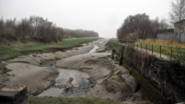
After initially following the railway the route then crosses a drainage channel and then works its way around the Point of Ayr Gas Terminal. http://en.wikipedia.org/wiki/Point_of_Ayr_Gas_Terminal

All the pipework gleamed in the sun.

This is the path to the east of terminal. It was on the left, to the right was a vast marshland nature reserve with just a glimpse of the Irish Sea ahead. http://www.rspb.org.uk/discoverandenjoynature/seenature/reserves/guide/d/dee-pointofayr/

After passing the caravan parks and holiday resort of Talacre it was out onto the sand dunes on the Point of Ayr.

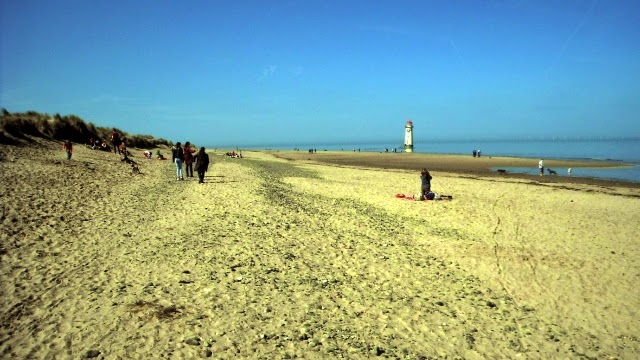
Bright sunshine and golden sands  as we walked towards the lighthouse. 

The sea was so calm and out at sea there was the sight of the wind turbines

The coast path follows the sea for about three miles, the sand near the seas was firm and the beach littered with star fish.
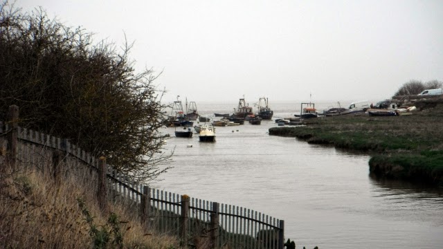
These swans did not mind being in a thick black muddy creek

The second section was through the Gronant Dunes Nature Reserve and this is the footpath into the dunes. http://www.greenlinks.org.uk/things-to-do/gronant-dunes-p314361

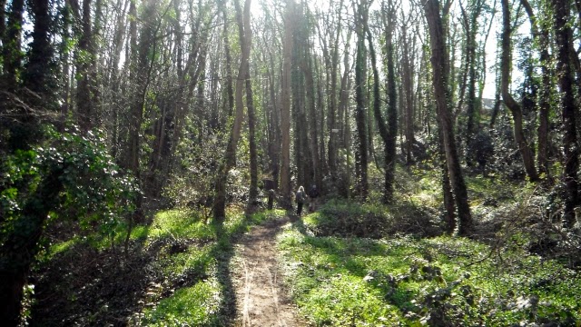
A beautiful walk through the dunes before we were to encounter 10 miles of sea front promenade.

We arrived in Prestatyn and had a fish and chip lunch in a bustling seaside café and also recalled another adventure as here was the marker at the northern end of the Offa's Dyke Path.
 
A flash back to 20th June 2009 Dave, Peter, Bob and me on completing the Offa's Dyke Path
 
The long sea wall at Prestatyn

The wall continues along the gap between Prestatyn and Rhyl where there is a golf course inland.

At the end of this curve in the wall Rhyl is reached. http://www.rhyl.com/
 
We collected the car near the Pavilion Theatre ( http://www.rhylpavilion.co.uk/ ) and returned to Chester after an 11-mile walk on a hot sunny day.

Friday, 17 April 2015

NORTH WALES COAST PATH

CHESTER TO THE MENAI BRIDGE

DAY TWO FLINT TO FFYONNONGROYW


We left Chester in two cars and left one at the north end of Ffyonnongroyw and then went to Flint Castle to start this second days walk. The mist had rolled in overnight and it was overcast as we started.
First we had a look around Flint Castle which was free to access. Not much of it left but it was atmospheric with the sea covered in fog and the land dark and overcast. Dave explored every part of it while the rest of us talked and took photos.

 We passed to the south of the castle and picked up this path which went around a wooded headland.

The water was coming in the creek that ends up near the Castle and there was a sand bar off shore.

The path then went inland again right around a creek that was Flint Harbour now devoid of boats and full of mud. http://www.cpat.org.uk/projects/longer/ports/ports.htm

We then followed the coast path along a wild shoreline .


After which came a stretch on a sea wall.

There were fields to the left sandwiched between the railway and the sea.

 We passed around this creek near Bagillt.
After Bagillt  the path goes around a headland which is higher than most of the rest of the coast line.

On the other side of the headland Bagillt harbour is reached with fishing boats still operating from it.

This is the view as one rounds the end of the creek via abridge.  

After another section of sea wall and passing an industrial estate Greenfield Dock is reached. Here we crossed the railway into Greenfield for a pie and drinks at the Packet Public House after 6 miles.

We then went to the nearby Basingwerk Abbey ruins again free to go in. http://en.wikipedia.org/wiki/Basingwerk_Abbey

The ruins


After looking at the fish in a nearby pond we returned to the coast and continued on a path next to large stones piled up along the shore. Periodically there were stiles with this unusual conversion for pedestrians so it could be kept locked to keep the sheep in the right fields.

The volume of stones deposited to protect this coast must have been enormous as it went on for over a mile.

The next creek Llannerch-y-môr contained the rusting remains of the Duke of Lancaster.  http://en.wikipedia.org/wiki/TSS_Duke_of_Lancaster_(1956)

To get around this creek we had to go under the railway to the coast road where there was a café where we had tea and coffee before returning up the other side of the creek.

We continued along the coast on this rough vehicular track and the Duke of Lancaster was soon lost in the mist behind.

Mostyn was the next village and here the coast is not an option. One has to choose between following the main road or taking an inland route through Mostyn and up through some woods. We took the inland route into the sunshine http://en.wikipedia.org/wiki/Mostyn

Once up on to the plateau the route follows a road under this unusual house built across the road.

After the road walking fields have to be crossed some laid out with numerous horse jumps.

The descent to Ffyonnongroyw was down a beautiful valley with a steep gorge and waterfalls below, one could almost forget the tired limbs as at the bottom on reaching our car the walk had been 13.70 miles. Then it was back to Chester having had a good and interesting day.

Wednesday, 15 April 2015

NORTH WALES COAST PATH

CHESTER TO THE MENAI BRIDGE

DAY ONE CHESTER TO FLINT 5 APRIL 2015


This was the first day of a seven day walk which involved 87.9 miles. We stayed for four nights at the Premier Inn 20-24 City Road, Chester CH1 3AE which was well located for  exploring the city centre. We used the NCP car park near the station which was £6 per day or £24 for a week. We took breakfast and evening meal at the Square Bottle.
http://en.wikipedia.org/wiki/Chester

We walked across the city centre via Eastgate Street, Watergate Street and New Crane Street down to the River Dee. The above is an old lock entrance to the canal network that runs through the city. http://en.wikipedia.org/wiki/Shropshire_Union_Canal

The banks of the River Dee from the parkland near Sealands Road. http://en.wikipedia.org/wiki/River_Dee,_Wales

This trip I was accompanied by Dave, Jim Tracey and Bob featured here at the markers indicating the start of the Wales Coast Path some 1.5 miles out of Chester. http://www.walescoastpath.gov.uk  

The canalised River Dee was dredged in vain to keep the port of Chester open to shipping. Most of the mornings walk was along a tarmac cycleway / footpath. I asked Bob what he thought of the walk so far and he replied - looks fairly straight forward.

The Ferry footbridge

 Next along the way was the Hawarden Airport but from the opposite bank we could see very little of it and continued keeping  one eye out for bikes and those on roller blades. http://en.wikipedia.org/wiki/Hawarden_Airport
The Airbus factory could be seen on the opposite bank and this dock is where the wings are loaded on to barges and transported downstream http://www.airbus.com/ All was quiet when we passed as it was Easter Sunday.

After 6 miles of walking we got to the A494 bridge over the River Dee and passed underneath with the Welsh Road bridge on the B5541 ahead in blue. Here the path was closed for reconstruction and we had to deviate through Garden City to get to it. Jo's café and the Queensferry Hotel had not opened yet to we continued

We crossed the River Dee via the Jubilee or Blue Bridge to continue on the south side. This is the view back. http://en.wikipedia.org/wiki/Jubilee_Bridge_(Queensferry) We had a picnic near a large electricity pylon and watched the water pouring upstream by the incoming tide.

The next bridge is the Hawarden Railway Bridge painted in white. http://en.wikipedia.org/wiki/Hawarden_Bridge

Closer view looking back.

On a wilder part of the river we had to deviate away from the River Dee to get a bridge over the Wepre Gutter which empties into the river.

 View from the bridge looking back along Wepre Gutter to the River Dee.

Next came the wharfs at Connah's Quay and this was the view across to the Corus Shotton Steel works. http://en.wikipedia.org/wiki/Connah's_Quay

This is the view from Connah's Quay down to the Flintshire Bridge http://en.wikipedia.org/wiki/Flintshire_Bridge

Another shot a bit further downstream.

The path crosses the main coastal railway and there is some road walking through Connah's Quay and we had a welcome pint in the Halfway House. 

As we walked on the environment was dominated by the Power Station http://en.wikipedia.org/wiki/Connah's_Quay_Power_Station

On reaching Pentre we left the coast road and crossed the railway into tidal marshland. The coastal path makes an interesting and potentially muddy way through the coastal margins.

On reaching higher grounds this is the view back.

 The walk ended at Flint Castle http://en.wikipedia.org/wiki/Flint_Castle

A match was in progress at Flint Town United's ground which was behind me as this shot was taken. http://www.pitchero.com/clubs/flinttownunited/
 
From here it was a short walk into town to the railway station and the return to Chester. We had walked 14 miles.