CIRENCESTER TO BATH MAINLY ON THE FOSSE WAY
17TH MARCH 2015 - CIRENCESTER TO CRUDWELL
It was up early and a full English Breakfast and then into the town to get some picnic materials for lunch on days three and four. The misty start was already giving way to week sunshine and the predictions for a good day encouraged us to start.
We left Cirencester via Querns Lane the Roman Via Principalis to visit the Roman amphitheatre on the south western edge of the town. This is an artists impression that is on display in the Corinium Museum and it had a seating capacity of 8,000.
The reality of what remains impresses, this is the approach from the road.
This is the centre with Dave giving some scale.
We started out on the A429 and the first section has a footway. This in the one mile marker.
We left the road, because the next few miles would be suicidal for pedestrians and followed the Monarch's Way http://www.monarchsway.50megs.com/ across the grounds of the Royal Agricultural University http://www.rau.ac.uk/
We also passed some waymarks for the Palladium Way http://www.ldwa.org.uk/ldp/members/show_publication.php?publication_id=9046 This is Ashwell Pool reached after 3.61 miles.
This is the view towards Bledisloe House from the path
These snowdrops are located on the outer edge of Trewsbury Camp Hill Fort http://www.british-history.ac.uk/rchme/ancient-glos/p32
On reaching the remains of the Thames and Severn Canal we diverted to have a look at the source of the River Thames. As is normal some stones where water gushes out occasionally marks the spot as does the wording on the marker stone behind it but there was no water to be seen despite it being March.
The next section was along the towpath of the Thames and Severn Canal which is part of the Thames and Severn Way and also the Wysis Way from Monmouth, one Dave and I have already done. This section is dry and could only be navigable if the former pumping stations could be activated to bring enough water to the surface. See www.cotswoldcanals.com
The towpath went under a bridge carrying a railway.
The Coates Round House. Photograph taken into the now glorious sunshine.
Tarlton Bridge carries the road between Tarlton and Coates and the towpath goes underneath.
This was the start of a short section where there was water in the canal.
This is the Coates Portal to the two-mile long Sapperton Tunnel where there has been a collapse of the roof, it is the fourth longest tunnel in Britain.
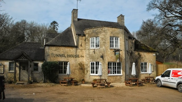
Lunch was taken after six miles at the nearby Tunnel House Inn and we were lucky enough to get our order in before a large party of ramblers arrived after their morning walk. www.tunnelhouse.com
Then it was on via Tarlton to Rodmarton where we paused on the seat just in the picture and explored the Church of St Matthew. http://en.wikipedia.org/wiki/Rodmarton
After that it was down a lane to cross the A433 onto the unsurfaced Stonehill Lane. We did stop to look at the disused railway line and the site of Rodmarton Halt but it was overgrown. The Lane continued across open fields to the Fosse Way to the South West of Kemble Airfield.
This is what we had come for, the relatively undamaged section of the Fosse Way.
We continued passing Fosse Gate and Ash Bed until we diverted off it along the path that led through Chedglow to Crudwell which was 1.61 miles off the Fosse Way.
Just before Chedglow we saw this huge field full of hundreds of chickens.
At West Crudwell we came across this unpleasant structure an electrified fence too high to step over and with no way of disconnecting it. I got a belt from it and took a step back. Using my insulated walking stick handle I managed to push it down. Not far enough as Dave got hooked up in it fell over and got several belts before extricating himself from it. It is being reported.
We continued to the Best Western Mayfield House Hotel in Crudwell for our overnight stay. www.mayfieldhousehotel.co.uk We walked SW down the A429 to the Wheatsheaf Inn for our evening meal although there is another pub the Potting Shed to the NE where we sampled some ale after the walk.
It was a 14-mile day.


No comments:
Post a Comment