Snowdon Range

Snowdon Range
Snowdon Range from Moelwyn Mawr

Sunday, 26 July 2015

ANGLES WAY JULY 2015 - DAY NINE

BARROW'S CORNER TO THETFORD

Summary - There was only 7 miles left to do so after an early start we were back in Thetford for lunch. This last section was also part of the St Edmund Way and mainly ancient track ways to start with and finishing across Barnhamcross Common.

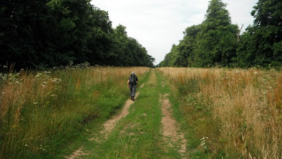
Because we only had four miles to drive to the start of the walk we were started on the Angles Way before nine in the morning. After parking near the B1106 it was back along yesterdays track passing the cottages and the pig farm to Barrow's Corner. There had been thunderstorms overnight so there were large puddles to avoid. The route in to Thetford was also part of the St Edmund Way and once again it was farm tracks with fields to the right and Albemarle Plantation on the left followed by Sandgault Plantation after that.

There were footprints of deer in the mud but we did not see any.

After crossing the Elveden Road the track continued with rough grassland on the right and Marmansgrave Wood on the left within which there was a herd of black sheep wet and no doubt thankful the eventful night was over.

The St Edmund Way is waymarked with these signs. A route across Suffolk, using the Stour Valley Path (East Anglia) to Sudbury and Long Melford and then going via Lavenham and Little Welnetham to Bury St Edmunds, burial place of the martyr King Edmund slain by the Danes in 869, along the waymarked Lark Valley Path (13 miles and included on OS mapping) to the Icknield Way Path at West Stow before striking over the Brecks to Thetford and the Hereward Way. Extract from https://www.ldwa.org.uk/ldp/members/show_path.php?path_name=St+Edmund+Way

Initially our way was north but then it turns east through woods to traverse Barnhamcross Common which is dissected by the Bury Road. It was here that we encountered our only problem on the route. At the point on the Ordnance Survey maps and the Norfolk County Council on-line maps show the Angles Way crossing the Bury Road some kind soul had dug deep trenches on both sides no doubt to keep vehicles off the Common. We crossed one to get onto the road but the ditch on the east side was too perilous to contemplate. We walked south along the Bury Road to a car park where we able to cross to the east side of the Common. We used the path up the east side to get to the urban edge of Thetford.

We could not find a point marking the end so we used the Nunnery Arch as our "end".
"The red-brick gateway which marked the entrance to the Place Farm or Nunnery at Thetford, is blocked by a wall and it is stated that this was built up seven times, and knocked down seven times by a carriage with four horses" (TL873823). My photo dates from the 1970s - the gateway is no longer blocked up nowadays. Extract from http://www.hiddenea.com/norfolkt.htm

We continued down the hill to the Nun's Bridge over the Little Ouse River which we followed through Thetford back to the Premier Inn (our base for five nights) for lunch in the Warrener Public House next door. This has a good value three course meal each day as well as a normal pub menu and is recommended.

On the way along the river we came across this statue of Captain Mainwaring from Dad's Army which was filmed in Thetford and there is even a museum http://www.dadsarmythetford.org.uk
In the picture is Jim who was my reliable companion on this trip.

ANGLES WAY JULY 2015 - DAY EIGHT

KNETTISHALL HEATH TO BARROW'S CORNER

Summary - Walked 11.2 miles today from Knettishall Heath, along the Angles Way Link to Barrow's Corner south west of Thetford. An easy day along ancient track ways so the going was easy and no stiles. Averaged 3.1 mph the fastest this holiday as a result. After starting at Knettishall Heath within 10 minutes we had got to the point where the Angles Way meets the Peddars Way and the Icknield Way. We were then on what is described as the Angles Way link to Thetford although it was today entirely on the Icknield Way which goes over a hundred miles to link up with the Ridgeway at Ivinghoe Beacon. We passed through the village of Euston but apart from that there were only a few other buildings on the route.

Knettishall Heath is in fact a diverse mosaic of habitats with woodland and riverside meadows, as well as large areas of heath. It extends to over 430 acres. The open landscape created by our Bronze Age ancestors 4,000 years ago had changed very little until the 20th century when forestry and modern farming transformed large parts of The Brecks. Knettishall Heath still retains a sense of what this ancient landscape must have looked like in the past. An extract from http://www.suffolkwildlifetrust.org/reserves/knettishall-heath
It was from one of the car parks at that location that we started this walk going west through heath and woods until we reached the Peddars Way one of the UK's National Long Distance Trails which follows a Roman Road north to meet the North Norfolk Coast Path at Holme-next-the-sea. http://www.nationaltrail.co.uk/peddars-way-and-norfolk-coast-path
 
It was just a few metres south to a road where the Peddars Way ends and the Icknield Way starts with the Angles Way using the same route initially. The Icknield Way runs 110 miles (177 km) to the Ivinghoe Beacon. http://www.icknieldwaypath.co.uk/

The day was going to be along tracks that were in use by a variety of other users and not cropped nor was progress to be slowed by gates or stiles. The first track had initially views east over another part of the Knettishall Heath and then passed Halfmoon Plantation and Thirty Acre Covert to a road.

From the road side we followed this sign containing the symbol for the Icknield Way.

Following a farm track through fields we came across this Ordnance Survey Trig Point at 49 metres although you would not see very far from its location nowadays.

Then we embarked on a section of a wide avenue between trees called Duke's Ride which leads in the direction of Euston Park and Euston Hall the home of the Duke of Grafton. www.eustonhall.co.uk  In 1666 Henry Bennet, later Earl of Arlington planted this avenue. http://list.historicengland.org.uk/resultsingle.aspx?uid=1000171
.
Still used by farm vehicles, sandy in parts, muddy in others it goes straight until you reach a point where you have to turn right where there is a distant view of the Hall and its grounds. After passing through a tree built it is west again and into the village of Euston.

This the war memorial and a green at an entrance to the Hall grounds.

A short section of the A1088 takes the Angles Way over the Black Bourn a tributary of the Little Ouse River.

The route is up Bury Lane another unsurfaced track. No sooner had I taken this photo of Jim ahead than a stag leapt out in front of him, ran down the track for 20 metres and then dived back in the undergrowth.

The route passes between fields crosses the Duke's Ride again and becomes the Euston Drove which leads all the way to Rymer Point on the A134. With no footway there is a dodgy section north along it for 400 metres to join another wide farm track heading west towards New Zealand cottages. A picnic lunch was taken on the track side.

After the cottages the track crosses a bridge of what is left of this disused railway track of the Thetford to Bury St Edmunds line that was opened in 1876, closed to passengers in 1953 and closed to all freight traffic in 1960. It was a 12.5 mile single track line. https://en.wikipedia.org/wiki/Thetford_to_Bury_St_Edmunds_line

The Angles Way continues north west. At a junction it was left south west towards a large forest and the junction with another track called the Elveden Road where it is right north west again along the edge of the forest.

The track then goes diagonally across two large fields, this is the first that had a healthy corn crop.

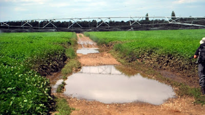
The second was a little more difficult. A potato crop was being automatically watered by this long mechanism that moved slowly cross the field. There was no way round we got a watering, fortunately it was a warm day!
At the other end of the field is a junction of tracks called Barrow's Corner which the Ordnance Survey Sheet indicates was on the line of the ancient Icknield Way although nothing can be seen on the ground. We left the Angles Way to walk along a track passing a pig farm and some cottages to the A1106 where we had left Jim's car.

Friday, 24 July 2015

ANGLES WAY JULY 2015 - DAY SEVEN

REDGRAVE AND LOPHAM FEN TO KNETTISHALL HEATH

Summary - A dry day with loads of fens to explore plus a windmill and a school to look at plus fish and chips in Hopton for lunch. Plenty of things to see which made for an enjoyable 10.6 miles.

Jim and I set off from the car park at the Redgrave and Lopham Fen National Nature Reserve. It is the largest valley fen in England and one of the most important Wetlands in Europe. This special place supports a diverse range of plants and animals, but it’s not just a fen. You can also explore the areas of woodland, heath and even follow the river Waveney that rises here. All was quiet as we were early and it was still damp underfoot. Passing some ponds and the Great Fen we made our way back to the Angles Way. The route soon crossed the River Waveney where a sluice mechanism enabled the water levels to be controlled upstream.
  

This is a view from the Way across the Middle Fen,

Next came the Little Fen and the lake that is the source of the River Waveney. In 1995 the reserve introduced a herd of Polish Konik ponies to graze the wetter areas of the fen. They were chosen over native breeds for their hardiness and ability to graze in very wet conditions and as this picture indicates we saw them at this spot. This marked the end of our journey from its confluence with the River Yare. Just across the B1113 is the source of the Little Ouse River which we to follow next.

After a short section of road walking we were back on footpaths sampling wild raspberries which led to Hinderclay Fen (photo). It comprises areas of wet fen (sedges, reeds and other wetland plants), scrub, woodland, acid grassland and small patches of heathland, on generally poor soils.
Valley fens, such as Hinderclay Fen, were too waterlogged and the soils too poor to cultivate but were once an essential source of basic materials for the poorer people of the parish. Traditionally, commoners cut peat for fuel, fen hay for animal fodder and bedding, and grazed livestock. Extract from http://www.lohp.org.uk/our-sites/hinderclay-fen the Little Ouse Headwaters Project web site.
It was time for a break on a seat and then on through Thelnetham Fen.

The next highlight was Thelnetham Windmill. It was not one of the open days so we were only able to have a look at the outside.
Dating from 1819, it is one of only four preserved tower mills in Suffolk. While working successfully during the 19th century, its condition deteriorated badly during the early 20th century and it had become effectively derelict by 1926. It was purchased for restoration by mill enthusiasts in 1979 who managed to complete this work by 1987. Extract from http://thelnethamwindmill.org.uk/

 We continued along a wide track to Kay's Farm and Spring Farm where it sounded as though there was target shooting going on in one of the buildings. Another long field side path plus some wild cherries and we were in Hopton. We made for the pub and found it did not open until 15:00 so resorted to more fish and chips from a wee shop and then went to  a seat in the churchyard to eat them.

 
Stomachs satisfied we ventured into All Saints Church where there was an overpowering smell of flowers from what was left of their flower festival. The roof beams were adorned by crudely carved figures at either end, something I cannot recall seeing elsewhere. http://www.suffolkchurches.co.uk/hopton.html

From Hopton the Angles Way follows the edges of fields around Hopton Fen. This is a gem of a site for the fen enthusiast. The waterlogged peat allows unique plants and animals to flourish. Bristling stands of saw sedge, reed and rushes dominate with scatterings of rare plants such as black bog rush, southern, marsh fragrant and early marsh orchid, adder’s tongue fern, twayblade and bogbean. Hemp agrimony and the azure blue Devil’s-bit scabious flower later in the season. Extract from http://www.suffolkwildlifetrust.org/reserves/hopton-fen
We continued west towards Lodge Farm and just before it we made our first crossing of the Little Ouse (photo above|) The course continues through Rushford, Thetford, Brandon, and Hockwold before the river joins the Great Ouse north of Littleport in Cambridgeshire. The total length is about 37 miles (60 km).

Exiting from Lodge Farm along its access road we passed through the hamlet of Gasthorpe and headed along another track that took us to this view of Riddlesworth Hall Preparatory School. http://www.riddlesworthhall.com/ It was built in1792 and was attended by Diana Princess of Wales (1961-1997)

Heading west along tracks with fields full of carrots we arrived at a road which took us over the Little Ouse again now a more substantial watercourse that goes along the side of Knettishall Country Park where we located Jim's car.
 

Thursday, 23 July 2015

ANGLES WAY JULY 2015 - DAY SIX

BILLINGFORD TO THE REDGRAVE AND LOPHAM NATURE RESERVE

Summary - It was dry all day today but it was so sticky and humid one felt it would not be long before there was a thunderstorm. We left Billingford and walked the 12.5 miles to  a car park in the Redgrave and Lopham Nature Reserve. Lots of field paths and all very pleasant but one could not describe the countryside as outstanding. Getting so fit that we did it in four hours of walking. We stopped at Diss for lunch - fish and chips and a cup of coffee. The walk finished through some marshy fens and the mosquitoes were all over the place - glad to get to the car.

Jim and I left the layby near Billingford on the A143 where we had finished the previous day. This meant returning along the main road buffeted by the draft of passing lorries back to the Angles Way. After a few hundred yards north along Kiln Lane it was west again along footpaths through Hall Farm and down to Norgate Lane where we had this view of Billingford Windmill. https://en.wikipedia.org/wiki/Billingford_Windmill

Another field later we were looking at these remains of St Mary's Church. Judging by older pictures it is gradually reducing in size. http://www.norfolkchurches.co.uk/thorpeparva/thorpeparva.htm

We went by Hall Farm cottages and some fields to Lodge Farm and onto the old Norwich Road now quiet because of the new dual carriageway just to the west - A140. It is a straight alignment because it is an old Roman Road to Venta Icenorum and passes through Scole to the south. https://en.wikipedia.org/wiki/Venta_Icenorum
 
We continued west via Scole Common and Miller's Lane to Frenze where we found a redundant church, St Andrew's which was a surprising break in our walk. It is a Grade 1 listed building and contained a number of tombs with brass plaques (see photos above and below). http://www.norfolkchurches.co.uk/frenze/frenze.htm


This is the view from the pulpit down on to the manorial box pew. Prior to the Reformation, seating was not customary in churches and only accorded to the lord of the manor, civic dignitaries and finally churchwardens. After 1569 stools and seating were installed in Protestant Churches primarily because the congregation were expected to listen to sermons, and various types of seating were introduced including the box pew. Someone had left extracts of speeches on the pulpit so I read them out to the assembled audience of one.

No sooner had we left the church than we were faced with a ford. Just made it with fractions left before an inundation into the boots.

It was soon under a railway and along Frenze Hall Lane into Diss one of the larger towns on the Angles Way. Opposite the 14th-century parish church of St. Mary the Virgin stands a 16th-century building known as the Dolphin House (photo above). This was one of the most important buildings in the town. Its impressive dressed-oak beams denote it as an important building, possibly a wool merchant's house. Formerly a pub, the Dolphin, from the 1800s to the 1960s, the building now houses a number of small businesses. Extract from https://en.wikipedia.org/wiki/Diss
Time for lunch and nearby we found an excellent Fish and Chips shop and a bank to get some money out.
 
The Angles Way then goes down the main high street through all the shops, quite a change from where we had been lately

Turning right of the high street we walked around a mere (lake) that covers 6 acres (2.4 ha). The mere is up to 18 feet (5.5 m) deep, although there is another 51 feet (16 m) of mud. There was also a layer of green algae on the surface which according to notices was a danger to human health. We left town via Fair Green and along the side of Roydon Fen - a boggy wood. Heading west and then south we crossed Doit Bridge over the River Waveney again.

The route was along minor roads through Wortham Ling (photo above) an area of wild heathland owned and managed by the Suffolk Wildlife Trust. It is 128.75 acres (51.5 hectares).

From there a pleasant path leads to Hall Farm next to which is this church. Another chance to take a break on a seat. The Church of St Mary has the largest round tower in England, ten metres across. http://www.suffolkchurches.co.uk/wortham.htm

The route was still west through a field of sugar beet and along this track to Woodhouse Farm where there was a nice path through the grounds. Then it was a track called Mill Lane north to Dashes Farm and Dashes Cottages after which it was a narrow path that led to a bridge over the River Waveney and into the Redgrave and Lopham Nature Reserve the largest fen in England where we had left a car in the Suffolk Wildlife Trust car park. I did not take any pictures of this nature reserve as the mosquitos were large numerous and biting. We were glad to get into the car away from them. http://www.suffolkwildlifetrust.org/reserves/redgrave-lopham-fen
 

Wednesday, 22 July 2015

ANGLES WAY JULY 2015 - WALK FIVE

HOMERSFIELD TO BILLINGFORD


Summary - Well it was a reasonable day despite the weather forecast. We set off from Homersfield basically following the course of the River Waveney but it was now reduced to a large stream and no longer the haunt of river boats. We passed through pretty Mendham and walked a round Harleston before the drizzle set in. Enough to need the cagoules but not enough to get us really wet. At 6.8 miles we could have diverted to Needham and a pub half a mile away but we decided to push on another 1.4 miles to Brockdish where there was another pub. We arrived as expected at about 13:00 only to find it was shut on Mondays! So I had to make do with a couple of crunchy bars that been in the rucksack for some time. The route continued following the river valley and was quite pretty. I was looking forward to the end of the walk because there was a burger bar there when we parked a car there this morning. Sadly the proprietor had gone home. 12.7 miles
We started from Homersfield and walked down the path to the Church of St Mary http://www.suffolkchurches.co.uk/homersfield.htm which is on higher ground above the River Waveney.

The Angles Way follows the Suffolk side of the river first on a road and then a footpath and there are views across Limbourne Common and the river to Norfolk and then the path goes around the base of Target Hill and onto another road into the village of Mendham.

Mendham's most famous son, born to a local miller, went on to become Sir Alfred James Munnings KCVO, PRA (8 October 1878 – 17 July 1959), known as one of England's finest painters of horses, and as an outspoken enemy of Modernism. An extract of one of his paintings, featuring a local lady, Charlotte Gray leading a white pony along the banks of the River Waveney, has been incorporated into the Mendham village sign. Charlotte Gray is buried in Mendham church. Extract from https://en.wikipedia.org/wiki/Mendham,_Suffolk

We stopped in the churchyard for a mid morning break and I ventured into the Church of All Saints and this is the main stained glass window. http://www.suffolkchurches.co.uk/mendham.htm
 
We crossed the River Waveney on leaving the village (photo above) and followed the path from Freston Farm towards Harleston.

This was the view looking back towards Mendham.
We crossed the A143 and through Briar Farm and into Harleston. I wish we could report something worth seeing in the town but the Angles Way turned south just as we got to the old part and we left through fields and crossed the A143 again.

After a short section of road running between the A143 and the River Waveney we crossed a couple of fields and across a footbridge where you get this view of a weir before skirting Weybread House.
The Angles Way follows the edge of the valley floor of the River Waveney on the south side and then passes through Instead Hall Farm onto Mill Lane where we had a decision to make. There was a pub in Needham half a mile to the north on the other side of the valley which was a one mile round trip but the next pub was 1.4 miles further along the Angles Way at Brockdish. We decided to push on and went through riverside fields occupied  first by horses and then a bull with herd whose posture caused us to divert through adjoining fields. We arrived as predicted at 13:00 just right for lunch at the Kings Head. With great disappointment it was found to be closed on Mondays. http://kingsheadbrockdish.co.uk/ Lunch was spent sitting on the village green in drizzle eating chewy bars that had been in the rucksack for weeks.
 
Walking on we went uphill along a road towards the A143 and just before it diverted along a path along field edges to the Church of St Peter and St Paul. It was locked. http://www.norfolkchurches.co.uk/brockdish/brockdish.htm
 
We continued keeping south of the A143 including using a section of the old road and then continued on a series of green lanes running along the north side of the River Waveney with strips of pasture leading down to the river with trees running in lines down to it. We reached the river again where the Angles Way meets the Mid Suffolk Footpath which runs for 20 miles through the attractive farmland of Mid Suffolk linking the busy town of Stowmarket in the south with the small village of Hoxne at its northern end. http://www.midsuffolk.gov.uk/leisure-and-culture/countryside/countryside-sites/the-mid-suffolk-footpath/
 
The Angles Way makes its way around the south side of this large field.
 
Part the way along this is the view down on the confluence of the River Waveney and the River Dove a tributary which has its source near Horham.
 
On reaching the A143 again we walked west along it towards a large layby where we had left Jim's car in the morning. The second disappointment was that the burger van that had been there in the morning had gone.