Snowdon Range

Snowdon Range
Snowdon Range from Moelwyn Mawr

Tuesday, 16 June 2015

CAMBRIAN WAY - JUNE 2015 - WALK TWO

THE ROMAN STEPS, CLIP, MOEL YSGYFANOGOD, MOEL Y GRYAFOLEN TO LYN TRAWSFYNYDD


This time we left one car on a road side verge near the camp site on the south side of Lyn Trawsfynydd and went in the other car back to the car park we ad used on Walk One near Graigddu-isaf. Having left there at 9:30 we would have rethought the day if we had realised that it would take 10 hours to do the walk of only 9.75 miles which was a reflexion of the terrain we had to cross.
Initially we had to retrace our steps of the previous day along the beautifully engineered path through the forest towards the pass to the north of Rhinog Fawr. On route we passed this lovely waterfall which is the one on the OS Sheets at GR 671299.

This is an extract from a display board which you see as you exit the forest and enter the Rhinog National Nature Reserve upon which I have added the route of the Cambrian Way in red.

After the forest the path was back to normal for this area but we made good progress towards the pass and where we had left off the previous day. At the pass we then started down hill on a path called The Roman Steps although it is believed to be of Medieval origin. At one time it may have been easy to walk but now the slabs of rock making up the path are eroded sometimes missing and at all angles. Progress was slow as we descended into a valley.  On route at 11:00 we paused for coffee.

The path led down to the end of a lovely valley called Cwm Bychan with woods and a lake called Llyn Cwm Bychan.

From here a signposted path starts straight up the other side and this is a view down across the lake as we climbed.

This picture is looking across at the route that we had taken down the Roman Steps and Rhinog Fawr is the one in the back.

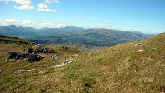
After climbing up for a about 20 minutes we joined another path heading north eastward but left it after half a mile to commence the ascent of Clip at 1937 feet. We approached it from the south west where the contours were less steep and found a very narrow path which led us with great difficulty to the top. By now it was 14:30 and our picnic lunch was taken on a flat rock out of the wind just below the summit. This was the view west towards Porthmadog and the sea.

This was the view south west back down the way we had come to Llyn Cwm Bychan.


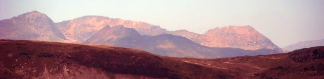
This was the view south east towards Rhinog Fawr. We had started  a couple of miles over the ridge to the left of it .

The summit cairn, there was another one nearby.
 

We then had to go along a long ridge which undulates along with lots of "Bwylch's" which means mountain passes but they turned out to be geological obstacles as the descends down cliffs and back up again were taking much care and time. In the background on this photo can be seen Snowdon on the left and in the centre the mountains where a mountain called Cnicht is located (more about that in future reports).

Looking back at Clip from further along the ridge.

Descending from Moel Ysgyfarnogod (623 metres) towards Foel Penolau.

As we approached the end of the ridge this is the view back.

This was the final obstacle Moel y Gyrafolen. We had come along the ridge from the right over the top and we were very fortunate to find a narrow path down the north side to the gate on the right and then to this point.

The descent was not yet over though because this is the view north east that we had to take through moorland to Lyn Trawsfynydd. By the time we reached the minor road near the lake it was 19:15 and we had to do the final half mile to the car along it. We had booked a table in Porthmadog for 19:30 but that was out of the window, fortunately Tesco was open to midnight and we were able to get a Shepherds Pie and vegetables to cook before tumbling shattered into bed!

Sunday, 14 June 2015

CAMBRIAN WAY - JUNE 2015 - WALK ONE

THE ASCENT OF RHINOG FAWR 720 METRES

Tony Drake's Cambrian Way runs from Cardiff to Conwy across some of the wildest and toughest terrain in Wales. http://www.cambrianway.org.uk/
 
Once again I returned to Wales to complete another section going north, This mountain is described in the guidebook as probably the rockiest mountain next to Tryfan. https://en.wikipedia.org/wiki/Rhinog_Fawr
 
Accompanied by Tracey and Jim we set off to it from a parking area near Graigddu-isaf at the end of a long minor road from the A470. GR 684 303. A footpath traverses a forest that has to be crossed to get to the base of the mountain.

A view of the mountains at the northern end of the Rhinogs where the path crosses a forest road. GR 673297.

The Fawr viewed from ladder stile at the exit from the forest at GR 671291.
 

View from a stile over a fence at GR 669289. A path runs towards the pass between Rhinog Fawr (Fawr = large) on the right and Rhinog Fach (Fach = small) on the left. https://en.wikipedia.org/wiki/Rhinog_Fach

As advocated by the late Tony Drake we started up from near a wall at GR 665283 and then on reaching a terrace worked north gradually climbing on a lightly cairned route. This is the view north east back across the forest we had traversed.

After about 500 metres we headed more directly towards the stony summit visible above. We found a minor track that enabled better progress. This is the Fach off to the south.

Picnic lunch was taken in this stone shelter out of the wind.

View south from the summit with Rhinog Fach on the left, Y Llethr in the centre and Lyn Hywel between them.

View north from the summit. The Cambrian Way descends to the green valley of Cwm Bychan on the left and then follows the ridge via Clip in the background.

In the background is the estuary where Porthmadog is located to the north-west.

The descent down the north side to Llyn (lake) Du was difficult as the path was very stony and steep before it was eroded by walkers. As per the guidebook we made for a wall off to the west and followed that down to the lake

We chose to traverse the lake via its north shore and then descended to follow the Nant Llyn-du (Nant = brook) back through the forest to the car. It was only 7.22 miles but it took us all day.

Sunday, 31 May 2015

COAST TO COAST MAY 2015 - DAY TEN

KIRKBY STEPHEN TO ROBIN HOOD'S BAY

DAY TEN - RUSWARP TO ROBIN HOOD'S BAY - 8 MILES

We chose to walk from our overnight stay at Ruswarp back to the route we had left at Hawsker.
Leaving the village behind we followed the Esk Valley Walk until we got to the track of the former railway line that used to run south to Scarborough.  http://en.wikipedia.org/wiki/Scarborough_and_Whitby_Railway
 
The route goes over a dramatic viaduct over the River Exe from which we got this view of Whitby Abbey http://www.english-heritage.org.uk/visit/places/whitby-abbey/
  
View off the viaduct up the Esk to Ruswarp.

View in the same direction later on from the former railway track. The track took us through Stainscare and Hawsker where we re-joined the Coast to Coast. After stopping in the cafĂ© at the caravan park in Hawsker Bottoms we continued to the coast.

Here the Coast to Coast joins the North York Moors Coast Path for the final three miles into Robin Hood's Bay.

The view from that point north towards Whitby.

Our route heading south east.

View from Clock Case Nab towards Normanby Stye Batts

Turning south west into Robin Hood's Bay we get the first view of the town. https://www.robin-hoods-bay.co.uk/

We descended down through the narrow streets to the bottom by the beach.

Tourist shops, cafes and pubs abound. I bought a tee-shirt and a rucksack badge. Dipped my boots in the sea and put the stone I had carried from the Irish Sea into the North Sea as tradition demands. The group had their photograph taken to record the completion of the expedition

I had a photograph taken at the finishing board attached to a wall opposite the Wainwright Bar and then made my way up through the town again to the Victoria Inn for lunch a few beers and then waited for the Packhorse mini-bus to take us back to Kirkby Stephen.
 
Thanks to Packhorse for sorting out the accommodation and the luggage transfers and for providing us with a framed certificate and thanks to my great companions in the Eastleigh Ramblers for their company and for putting up with me always being at the back taking photos.
 
Keep watching the blog, June's adventure is the Rhinogs and Snowdonia along the Cambrian Way
 

COAST TO COAST MAY 2015 - DAY NINE

KIRKBY STEPHEN TO ROBIN HOOD'S BAY

DAY NINE - EGTON BRIDGE TO HAWSKER - 14.23 MILES

A beautiful day for a walk - the last long one before the end.
As the rest of the party hung about waiting for those who had gone to the stepping stones over the Esk to get some pictures two set off in the morning sunshine.

Egton Hall from the rear. A large part of the area is the Egton Estate.
Between Egton Bridge and Grosmont an old toll road is used and this is a sign attached to the side of Beckside Farm half way along.

Grosmont is a beautiful village at the junction of the main railway line from Middlesbrough to Whitby and the private North York Moors Railway which runs south to Pickering. http://www.nymr.co.uk/ We hung around waiting for the steam train to leave.

 From here it is a steep climb up a road to the top of the moors. This is the view half way up. The route we had followed came over the moors at the back and right along the wooded valley.

At the top we left the road on Sheep House Rigg to see a line of stones called the Low Bride Stones.

We then climbed along the ridge to inspect another collection called the High Bride Stones where we had a coffee stop.

The path across Sleights Moor towards the A169

The descent from the A169 towards Little Beck.

Once down in the valley bottom the route follows a beck up to a waterfall called Falling Foss.

A mineral working on the way up.

The Hermitage a rock hollowed out as a hermit's cave, reputedly by a George Chubb in 1790, on top of which is two wishing chairs carved of stone.

Beside this large waterfall is http://www.fallingfossteagarden.co.uk/ where we stopped for drinks and cakes.
Video of the restoration of the tea garden https://www.youtube.com/watch?v=-tcxwM2zAT4
 

We were only half way and it was well into the afternoon because of time spent watching railway trains and visiting cafes so it was on up May Beck with earnest  to get back to the moors.

Having got out of the trees we could look back to the way we had come.

The route then crosses Sneaton Low Moor and the Graystone Hills, looking back it was moor as far as you could see. On arriving at Hawsker we diverted to the Hare and Hounds for a drink. http://www.hareandhoundshawsker.co.uk/Site/Home.html Because of the size of our party we were taken off route by taxi to Ruswarp on the River Exe. http://en.wikipedia.org/wiki/Ruswarp

We stayed overnight at Ruswarp Hall http://www.ruswarphallhotel.co.uk/ and had our evening meal at the Bridge Inn.