THE ROMAN STEPS, CLIP, MOEL YSGYFANOGOD, MOEL Y GRYAFOLEN TO LYN TRAWSFYNYDD
This time we left one car on a road side verge near the camp site on the south side of Lyn Trawsfynydd and went in the other car back to the car park we ad used on Walk One near Graigddu-isaf. Having left there at 9:30 we would have rethought the day if we had realised that it would take 10 hours to do the walk of only 9.75 miles which was a reflexion of the terrain we had to cross.
Initially we had to retrace our steps of the previous day along the beautifully engineered path through the forest towards the pass to the north of Rhinog Fawr. On route we passed this lovely waterfall which is the one on the OS Sheets at GR 671299.
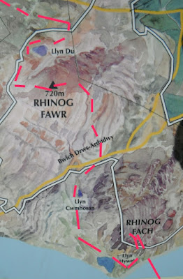
This is an extract from a display board which you see as you exit the forest and enter the Rhinog National Nature Reserve upon which I have added the route of the Cambrian Way in red.
After the forest the path was back to normal for this area but we made good progress towards the pass and where we had left off the previous day. At the pass we then started down hill on a path called The Roman Steps although it is believed to be of Medieval origin. At one time it may have been easy to walk but now the slabs of rock making up the path are eroded sometimes missing and at all angles. Progress was slow as we descended into a valley. On route at 11:00 we paused for coffee.
The path led down to the end of a lovely valley called Cwm Bychan with woods and a lake called Llyn Cwm Bychan.
From here a signposted path starts straight up the other side and this is a view down across the lake as we climbed.
This picture is looking across at the route that we had taken down the Roman Steps and Rhinog Fawr is the one in the back.
After climbing up for a about 20 minutes we joined another path heading north eastward but left it after half a mile to commence the ascent of Clip at 1937 feet. We approached it from the south west where the contours were less steep and found a very narrow path which led us with great difficulty to the top. By now it was 14:30 and our picnic lunch was taken on a flat rock out of the wind just below the summit. This was the view west towards Porthmadog and the sea.
This was the view south west back down the way we had come to Llyn Cwm Bychan.
This was the view south east towards Rhinog Fawr. We had started a couple of miles over the ridge to the left of it .
The summit cairn, there was another one nearby.
We then had to go along a long ridge which undulates along with lots of "Bwylch's" which means mountain passes but they turned out to be geological obstacles as the descends down cliffs and back up again were taking much care and time. In the background on this photo can be seen Snowdon on the left and in the centre the mountains where a mountain called Cnicht is located (more about that in future reports).
Looking back at Clip from further along the ridge.
Descending from Moel Ysgyfarnogod (623 metres) towards Foel Penolau.
As we approached the end of the ridge this is the view back.
This was the final obstacle Moel y Gyrafolen. We had come along the ridge from the right over the top and we were very fortunate to find a narrow path down the north side to the gate on the right and then to this point.
The descent was not yet over though because this is the view north east that we had to take through moorland to Lyn Trawsfynydd. By the time we reached the minor road near the lake it was 19:15 and we had to do the final half mile to the car along it. We had booked a table in Porthmadog for 19:30 but that was out of the window, fortunately Tesco was open to midnight and we were able to get a Shepherds Pie and vegetables to cook before tumbling shattered into bed!


No comments:
Post a Comment